|
|
|
A visit to the Calf of Man
 |
The Calf has had several names, Kalfr (small
island near a larger one) - by Norsemen. Le Calf - on Manorial Roll of
151,. Yn Calloc - Manx, Yn Kellagh (the Cock) - as it is called by Manx
Fishermen.
Separated from the main island by the Sound, a dangerous strip of sea about ¼ mile wide, the Calf lies off the south of Mann. Its coastline measures about 5 miles and it measures about 1½ miles long by 1 mile wide. The highest point is on the north coast - 421ft. The highest cliff - called Oirr Vooar is 400ft. There are four harbours. In the north lies Cow Harbour, named because it was to this harbour - that cows were swum when the island was farmed. Between Cow Harbour and the Cletts are the small Grants and Careys Harbours. The largest harbour is South Harbour. This is the one to which supplies for the lighthouse are brought. The storehouse here was probably built at the same time as the first lighthouse. There are also several other landing places known in Manx as Giau. On the east coast is Giau Yiarn and, on the south coast Mill Giau, into which the mill stream used to run and which opens out into the Puddle. |
On the west coast is the inlet, Giau Lang and at its head is a small cave which dries out at low tide. In the roof is a man-made shaft, roughly 30 feet high. The story is that smugglers used it to bring in their goods. Near the top of the shaft is a vertical stone, about 3 feet high, on which the smugglers are said to have hung their lanterns to guide in their boats at night.
| There are four islets off the coast,
Kitterland, Thousa, The Burroo and the Stack. The largest, Kitterland, has
about an acre of pasture on it. The late Thoas Clague used to place lambs
on Kitterland in the Spring and leave them there to fatten.
Kitterland is supposed to have received its name from the famous Viking Chief of King Olaf's day - Kitter. Kitter was a mighty hunter and over the years managed to slaughter most of the wildlife in the southern part of the Isle of Man. One day he was told that the Calf contained some splendid red deer, so he left his house on South Barrule with a hunting party. The men of the south of the island feared that when he had finished off the deer he would start on their cattle. They thought that, if he lost his house, he might leave the island. So, by means of Witchcraft, they set fire to Kitter's house. Kitter's cook, who had been left behind to guard the house and who had a mighty loud voice, called out to Kitter who came hurrying home. He left the Calf to cross the Sound in a coracle (round boat). Unfortunately the tide had changed and the coracle smashed into what we now call Kitterland and all were drowned. |
 |
There are also dangerous rocks off the Calf. The Cletts, where often seals are seen and Chickens Rock, on which a lighthouse was built.
There is one road on the Calf and it joins the two main harbours with the lighthouse complex and the farmhouse. This Farmhouse was used as such for many years until it became a bird observatory in 1959. Today, a warden lives here during the summer months and spends much of his time ringing birds, especially those who rest briefly on the Calf when migrating northwards in spring and southwards in autumn. You will notice a bird trap near the farmhouse/observatory and mist nets in different parts of the island.
Between the observatory and the north of the island is Janets House - which can be reached by branching to the right off the main track going north towards Cow Harbour. This building was shown as the Mansion House on the Richard Wilson Map of 1771, though the present structure dates from about 1890, when it was rebuilt. There is a small quarry at the back from which the building stone was obtained and there is a spring which supplies fresh water. The last people to live there were a group of labourers who were employed in building a new dock at Cow Harbour at the beginning of this century.
Going South from the farmhouse/observatory is to be found the smithy and also a modern silo. And further on, at the crossroads, a nineteenth century mill. And towards the lighthouses lie some deserted buildings, largely domestic accommodation.
 |
Many different sorts have lived on the Calf
over the years. Attempts have been made to farm it - you might well notice
the Lazy Beds both north of the observatory and near South Harbour,
probably used by Celtic Farmers. More modern farmers have tended to use
the richer lands of the centre of the island, some of which have been
bounded with stone walls. Even today, Manx Heritage keeps a flock of
Loghtan Sheep here. They are looked after by the Manager of Church Farm,
Cregneish.
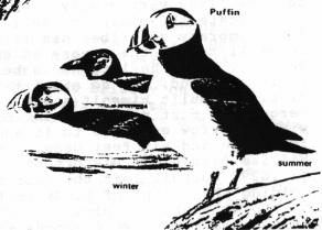
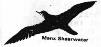
Over the centuries man has used the island as a food resource. Shearwater and Puffins were hunted in their tens of thousands; unsuccessful attempts were made to introduce deer and successful attempts were made to introduce rabbits. Now rabbits are everywhere and are very tame. |
There has also been some mining. In 1292, King Edward granted a licence to John Comyn, the Earl of Buchan, to mine lead to roof the turrets of his castle in Galloway. Between the 15th & 17th centuries, the Stanleys prospected for copper and, even in 1773 when the Duke of Atholl leased the Calf to John Quayle, the agreement showed that he did not lease the mineral rights. Both lead and copper were found at Caigher Point. Bushell, himself, was a mining engineer, which perhaps attracted him to the Calf in the first place.
West of the observatory and north of the lighthouses, you will find on the map the site of Bushell's House. On the ground there are still the remains of the building - sited on the highest point in the vicinity and with wonderful views. Bushell was the third of three hermits (there may have been more) who sought refuge over the years. He was born in Broad Marston in Gos, in 1594, the second son and perhaps at odds with his family as he left home at fifteen. He entered the service of Sir Francis Bacon, who seems to have been responsible for his going to Balliol College, Oxford. When Bacon became Lord Chancellor, he took Bushell to Court with him. Bushell became a dandy and speculator and fell into debt. Several times, Bacon bailed him out of trouble but when he, himself, fell foul of the law, Bushell fled; first to the Isle of Wight where he lived as a fisherman and then, after 1626 - when Bacon died - to become a hermit on the Calf. He claimed that he wished to repent for his past sins and debauchery. During the three years be lived on the Calf, Bushell claimed to have lived very simply. Whether he used his mining skills to investigate the mining potential of the island is not known. A contemporary described his life... "All Man much glorieth in the Calf and do still retain the memory of the vast wit for inventions, Mr.Thomas Bushell, where he late had a hermitical life in ye cave in a hollow rock in this island, and do still talk of his pendant bed (hammock) and strange diet. He built himself a hut on the very summit of the island on the verge of a most perpendicular precipice. It consists of a single room with a narrow entrance to it and, at one side a recess of about three feet wide and six feet deep, probably intended to contain a bed..."(from William Blundell's History of the Isle of Man). In 1629, Bushell left the Calf and led an adventurous life, including holding the island of Lundy in the King's Name until 1647 and starting the Welsh Mint. He died, in debt, at the age of 80 in 1674 and is buried in an unmarked grave (records incomplete) in Westminster Abbey.
There were two other earlier hermits on the Calf. In the eighth century - a monk who may have built his keeil near Jane's House and in the sixteenth century a man who had slain a woman and who in a fit of remorse isolated himself on the Calf.
 |
The earliest references to lighthouses on the Calf are in 1771, when Richard Wilson's map shows two coal-burning lighthouses, one opposite Burroo and one near Bushell's house. If they did exist, they would have been useful only to local fishermen. By the end of the eighteenth century, shipowners were becoming increasingly concerned about the number of ships lost off the Calf. In 1794, nine ships were lost. Since 1771 representations had been made to the Dukes of Atholl, with little result until, in 1815, the Commissioners of the Northern Lights wrote to the then Duke, expressing their concern. It took a further two years, for the Duke demanded heavy ground rent for the land to be used for the lighthouse. |
Finally £10 pa was agreed and the first two lighthouses were built and commissioned in 1818. The two were built in line to indicate to ships the place where Chicken's Rocks lay. In 1875 a lighthouse was built on Chicken's Rock itself, and a fog signal was added in 1890. In 1960, this was destroyed by fire. When a new lighthouse was built on the Calf after this, the one on the Calf was used as an unmanned light. It is worth looking to see how the lighthouses line up with each other and, if you are lucky, you will see Chough flying near the old lighthouses for here they build their nests.
Today the Calf is administered by Manx Heritage as a Wildlife Sanctuary and we are asked to respect it as such.
| One of the hazards
of living the sporting life on the calf was described by Maxwell Fraser in
his book In praise of manxland.
"For rabbits hot and rabbits cold For rabbits young and rabbits old For rabbits tender rabbits tough I thank the Lord I've had enough!" |
 |
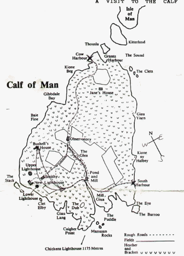
Among the Birds which nest on the Calf are the following:
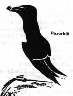
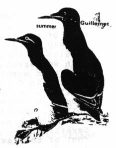
Blackbird - Chaffinch - Chuff - Cormorant - Cuckoo - Dunnock - Fulmar - Grasshopper Warbler - Great Black-Backed Gull - Guillemot - Herring Gull - Hooded Crow - House Sparrow - Kestrel - Kittiwake - Lapwing - Lesser Black-Backed Gull - Linnet - Magpie - Mallard - Meadow Pipit - Mistle Thrush - Moorhen - Oystercatcher - Partridge - Puffin - Raven - Razorbill - Reed Bunting - Robin - Rock Pipit - Sedge Warbler - Shag - Short-Eared Owl - Skylark - Spotted Flycatcher - Starling - Stonechat - Swallow - Wheatear - Whitethroat - Wood Pigeon - Wren.
When the Calf was put up for sale in 1931, it was valued at £3,000. The advertisement mentioned 89 acres of fenced-in land, 61 being pastural and 28 arable; it also listed:
House - 2 sitting rooms, dairy, pantry, four bedrooms, and boxroom.
Farmhouse - Kitchen, back kitchen, 3 bedrooms.
Buildings - Stable, hay loft, barn, pigstyes, 3 cowhouses, 2 outhouses, cart shed, coach house, poultry house. New Silo, paddock, and kitchen garden.
Lower Lighthouse - Converted into dwelling, dining room, kitchen, scullery, pantry, bathroom, 3 bedrooms, boxroom, Smoking room in lighthouse, and gardens.
Jane's Cottage - Three rooms on ground floor.
South Harbour - Wharf and storehouse
Approach from Calf Sound - Newly constructed wharf which can be approached at high or low tide, also boathouse that can be approached with slide and winch.
Roads - A road that runs straight across the island to the lighthouses, and also down to South Harbour.
Water Supply - Is ample.
![]()
TheSargents Back to Homepage
I.O.M. Links Next page